IN Brief:
- Chimera Land is designed to support armoured and autonomous vehicle navigation in GNSS-denied environments.
- The sensor provides 3D body velocity data to an inertial navigation system without contacting the ground.
- The launch reflects growing demand for resilient PNT subsystems across land platforms and unmanned vehicles.
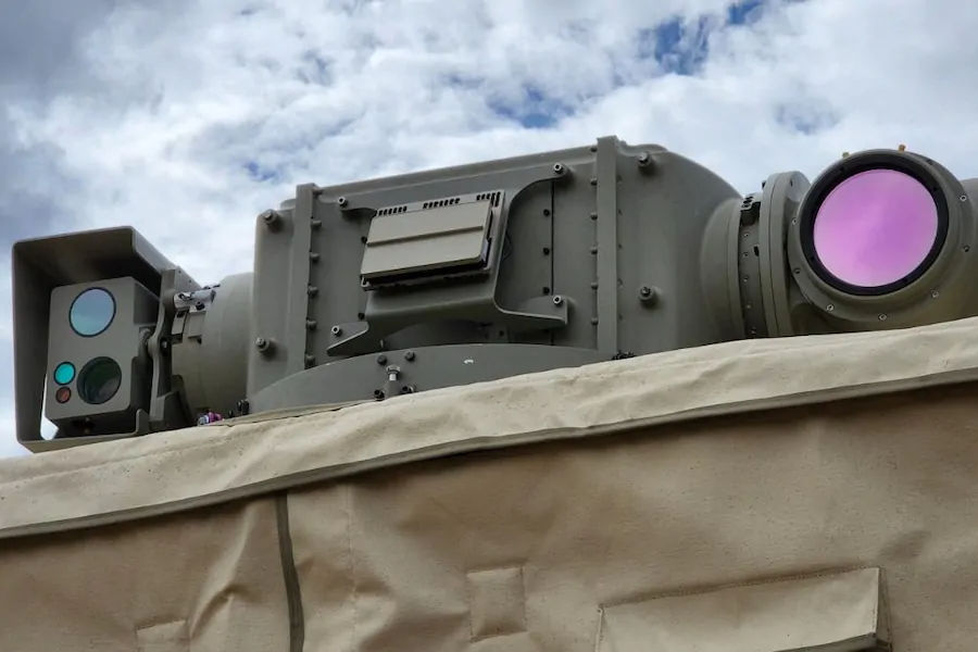
Advanced Navigation has launched Chimera Land, a laser velocity sensor designed to improve vehicle navigation in environments where satellite positioning is jammed, spoofed, degraded, or unavailable.
The system uses non-contact laser velocity sensing, feeding 3D body velocity data directly to an inertial navigation system. When paired with Advanced Navigation’s Boreas D90, it is designed to support low-drift dead reckoning across defence and heavy industrial vehicle applications. The sensor is also built for integration with the company’s Boreas and Certus Evo inertial navigation ecosystem, with interfaces including Ethernet, RS232, PPS, and laser enable.
Armoured vehicles, reconnaissance vehicles, remote weapon stations, autonomous ground systems, and logistics vehicles are all becoming more dependent on precise position, navigation, and timing data. GNSS has made that easier for decades, but its vulnerability is now shaping platform design from the beginning. Jamming and spoofing are no longer specialist edge cases; they are routine features of contested electromagnetic environments.
Chimera Land is aimed squarely at that problem. A laser velocity sensor can help a vehicle maintain accurate navigation by measuring motion relative to the surface below, rather than relying solely on satellite updates. For tracked and wheeled military vehicles, that can reduce drift in inertial systems, support fire-control alignment, improve autonomous route execution, and maintain situational awareness when external signals become unreliable.
The manufacturing challenge sits in the subsystem bay rather than the platform brochure. Modern armoured vehicle programmes are no longer judged only by armour, mobility, and weapon fit. They increasingly depend on internal digital architectures: inertial navigation, edge computing, mission networks, sensor fusion, active protection interfaces, and electronic warfare resilience. Each subsystem has to survive vibration, shock, dust, water, temperature extremes, power instability, and electromagnetic interference.
Chimera Land has been designed with military environmental and electromagnetic standards in mind, which is increasingly essential for suppliers targeting vehicle integration. Size, weight, power draw, mounting geometry, optical-head arrangement, and interface choices all affect whether a sensor can be integrated without forcing a broader redesign. Vehicle interiors are already crowded, especially when autonomy, counter-drone systems, communications upgrades, and power-management equipment are being added to existing fleets.
The loss-of-GNSS pressure behind Chimera Land is part of a wider resilience problem already reshaping commercial and military GPS dependence. Land forces face a particularly unforgiving version of it. A vehicle that cannot trust its position cannot confidently coordinate fires, avoid fratricide, execute autonomous tasks, or navigate complex terrain under emissions control.
Resilient PNT is becoming an industrial category in its own right. Suppliers that once sold navigation as a component are increasingly expected to deliver mission-critical resilience, with evidence of reliability, repeatable calibration, cybersecurity assurance, integration support, and long-term parts availability. A small sensor can therefore carry a substantial qualification trail, especially when it becomes part of fire-control, autonomy, or command-system architecture.
Australia’s position in this market is also strengthening. The country has been building a defence-industrial base around land vehicles, autonomous systems, electronic warfare, and advanced manufacturing, while operating in a region where long-range deployment and communications denial shape planning assumptions. Navigation subsystems designed for Australian defence requirements may therefore have export relevance across partner fleets modernising armoured and autonomous vehicle capabilities.
Field performance will decide whether Chimera Land becomes a routine integration option. Land vehicles are brutal environments for precision sensors, with mud, optical contamination, vibration, heat, rapid manoeuvre, imperfect mounting, and crew-level maintenance all working against laboratory performance. A system that performs well in controlled testing has to prove itself across vehicle classes, terrains, and operational profiles.
Chimera Land’s launch belongs to the quiet rebuild of the military vehicle electronics stack. Armour and firepower still dominate the imagery, but survivability also depends on knowing where the vehicle is when the spectrum has been deliberately corrupted. Dead reckoning has moved from legacy navigation method to modern battlefield resilience requirement.