IN Brief:
- Ocean Power Technologies is one of six potential awardees under a US Navy ocean-mapping framework.
- The $40 million ceiling is shared across every participant, with individual task orders competed separately.
- The ordering period is expected to run from August 2026 until July 2028.
Ocean Power Technologies has been selected as one of six potential awardees under a US Navy contract framework for high-resolution seabed mapping using long-endurance uncrewed surface vessels.
The multiple-award, indefinite-delivery/indefinite-quantity contract carries an aggregate ceiling of $40 million across all six participants. Individual task orders will be competed among the contract holders, leaving Ocean Power Technologies with an approved route to pursue work rather than a guaranteed share of the ceiling.
The Naval Oceanographic Office, known as NAVOCEANO, intends to use the framework for missions across the Indian and Pacific Ocean basins. Its two-year ordering period is expected to begin in August 2026 and continue until July 2028, with precise locations and requirements determined by individual task orders.
No funded task order, vessel quantity, mission schedule, or revenue value has yet been assigned to Ocean Power Technologies. The distinction matters because the $40 million figure is the maximum shared capacity of the complete framework, not an order placed with one company.
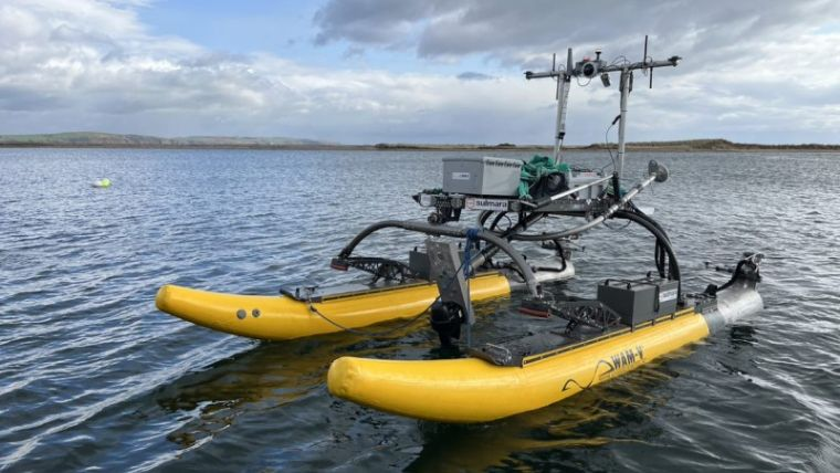
Ocean Power Technologies develops the Wave Adaptive Modular Vessel, or WAM-V, family of uncrewed surface vessels alongside PowerBuoy offshore energy and communications platforms. The company has positioned these systems as an integrated maritime operating infrastructure covering vehicles, sensors, data, remote operations, and support services.
Its WAM-V vessels use an articulating structure intended to isolate the payload platform from some hull movement. Available configurations can carry hydrographic, environmental, security, and other mission equipment, although the Navy announcement does not identify which vessel size or sensor package Ocean Power Technologies would offer for a future mapping task.
The company has previously demonstrated a WAM-V 22 conducting multi-day offshore survey operations while carrying a seabed-mapping payload. That work provides relevant experience, but it should not be confused with acceptance under the new Navy framework or evidence that the same configuration will be selected.
High-resolution seabed mapping depends on more than deploying an autonomous craft for several days. The vessel must follow planned survey lines with sufficient accuracy, maintain stable sensor geometry, manage currents and sea state, and collect data that can be processed into a consistent representation of the ocean floor.
Hydrographic payloads also require calibration, sound-velocity information, reliable positioning, and disciplined quality control. A vehicle may complete its route and still produce a poor dataset if motion, sensor alignment, navigation errors, or environmental conditions are not identified during collection and processing.
Autonomy shifts the operating burden rather than removing it. Mission planners must define the survey area and operating limits, remote supervisors must monitor vehicle health and traffic, and hydrographers must validate the final data. Maintainers, communications specialists, and recovery teams remain necessary even when no crew is carried aboard the platform.
The Indian and Pacific Ocean operating area will test that support model across long distances and varying conditions. Weather, shipping lanes, fishing activity, remote launch points, limited communications, and the availability of recovery vessels can all affect the usefulness of a nominally long-endurance system.
The contract announcement does not state whether selected vessels will deploy independently from shore, operate from a larger ship, or use regional ports. Those arrangements will influence mobilisation cost, mission endurance, maintenance requirements, and how quickly an awardee can respond to an individual task order.
Ocean Power Technologies has been developing a Robotics as a Service approach in which customers procure access to vehicles, mission operation, and data support rather than buying equipment alone. A competed mapping framework offers a practical route for that model, because NAVOCEANO can define a required survey output while leaving the contractor to organise the supporting platform and personnel.
The commercial attraction is accompanied by delivery risk. Six companies can compete for each task order, and selection will depend on price, mobilisation time, vessel availability, sensor performance, operational reliability, and confidence in the resulting data. Merely holding a position on the framework does not establish recurring work.
Small uncrewed vessels can extend oceanographic collection without committing a survey ship and crew to every task. They may also operate several missions in parallel, although their payload, endurance, weather tolerance, and communications capacity remain below those of larger platforms.
That makes mission matching important. An autonomous vessel suited to a contained coastal survey may not be appropriate for a remote deep-ocean task, while a larger vehicle can become unnecessarily expensive where the survey area is accessible and conditions are moderate.
The framework gives the Navy a mechanism to compare those approaches through competed requirements rather than selecting one system for every mission. It also gives Ocean Power Technologies an opportunity to convert earlier demonstrations and commercial operating experience into accepted government survey output.
The first meaningful milestone will be a funded task order identifying the area, performance standard, and selected platform. Until then, the $40 million ceiling describes the size of the competitive framework, while Ocean Power Technologies holds one of six tickets to enter it.